
Crime rates tumble as Los Angeles stays home


Los Angeles is now in its sixth week since Mayor Eric Garcetti issued his “safer at home” order requiring residents to practice social distancing to flatten the coronavirus curve. So far, it’s crime rates that have flattened dramatically.
Although it is unfortunate for anyone whose hobbies consist of going to non-essential businesses (Hi, nail salon! I miss you!), we have been tracking how closing down much of the city has led to an overall drop in crime, making neighborhoods safer for Angelenos.
The first three months of 2020 show an abrupt dropoff from the previous year because the second half of March was impacted by the stay-at-home orders. That led to a broad reduction in offenses such as simple assault, stolen cars and burglary from vehicles. The first quarter of the year was down 14.5% compared with the same period in 2019, according to Los Angeles Police Department data,

April is on track to see dramatic declines in overall crime. During the first 18 days of the month, overall crime was down 27% compared to the same time last year.
The City of Los Angeles was already experiencing a reduction in crime before coronavirus began to spread this year. There was a 5% reduction in overall crime last year from a year earlier. But the drop was not felt equally across the city. Some neighborhoods saw declines, while others saw big increases.
Of the 110 neighborhoods in Los Angeles we track, 81 saw a decrease during the first three months of the year, seven saw no change and 22 registered increases.
During the first quarter, Sherman Oaks, Mount Washington and West Adams saw the sharpest decline, with drops of 48%, 36% and 28%, respectively. Carthay and West Los Angeles saw increases in overall crime, despite most of the city being shut down, with spikes of 37% and 35%, respectively. Elysian Park, the neighborhood around Dodger Stadium, had the biggest increase, at 91%, however the overall number of reported crimes was still small, at 63.
See how your neighborhood fared during there first three months of 2020. (Crime rate is the number of crimes per 100,000 residents.)
| Neighborhood | Total reported crimes Jan.-March 2020 | Total reported crimes Jan.-March 2019 | Total population | % change | Crime rate Jan.-March 2020 |
| Elysian Park | 63 | 33 | 2386 | 91% | 2640 |
| Carthay | 85 | 62 | 5356 | 37% | 1587 |
| West Los Angeles | 181 | 134 | 12888 | 35% | 1404 |
| Bel-Air | 47 | 36 | 7615 | 31% | 617 |
| El Sereno | 382 | 305 | 42077 | 25% | 908 |
| Chinatown | 203 | 167 | 13687 | 22% | 1483 |
| Reseda | 737 | 627 | 71569 | 18% | 1030 |
| Wilmington | 679 | 580 | 58161 | 17% | 1167 |
| Century City | 127 | 112 | 6175 | 13% | 2057 |
| Lakeview Terrace | 90 | 80 | 13579 | 13% | 663 |
| Pico-Robertson | 210 | 189 | 18307 | 11% | 1147 |
| Mar Vista | 247 | 226 | 37833 | 9% | 653 |
| Sunland | 133 | 122 | 14614 | 9% | 910 |
| Tujunga | 181 | 170 | 27328 | 6% | 662 |
| Sylmar | 684 | 645 | 80327 | 6% | 852 |
| Gramercy Park | 169 | 161 | 10666 | 5% | 1584 |
| Green Meadows | 600 | 580 | 34848 | 3% | 1722 |
| Shadow Hills | 99 | 96 | 12999 | 3% | 762 |
| Vermont Slauson | 602 | 589 | 21634 | 2% | 2783 |
| Palms | 390 | 382 | 42746 | 2% | 912 |
| Harbor Gateway | 488 | 482 | 41308 | 1% | 1181 |
| Arleta | 204 | 202 | 33780 | 1% | 604 |
| Adams-Normandie | 214 | 213 | 17925 | 0% | 1194 |
| Westlake | 1529 | 1522 | 107760 | 0% | 1419 |
| Florence | 930 | 926 | 52639 | 0% | 1767 |
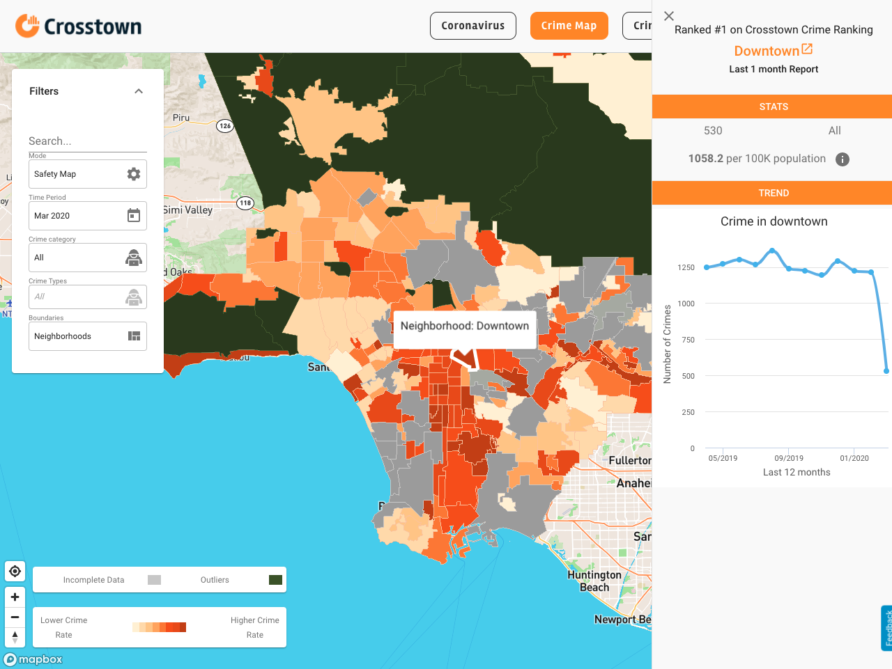
| Downtown | 3392 | 3391 | 50085 | 0% | 6772 |
| Playa Del Rey | 104 | 104 | 11434 | 0% | 910 |
| Vermont Vista | 492 | 493 | 49385 | 0% | 996 |
| Echo Park | 421 | 422 | 34950 | 0% | 1205 |
| Pacific Palisades | 138 | 139 | 24990 | -1% | 552 |
| Arlington Heights | 244 | 246 | 23768 | -1% | 1027 |
| Harvard Heights | 258 | 261 | 19497 | -1% | 1323 |
| Northridge | 749 | 759 | 67555 | -1% | 1109 |
| Watts | 590 | 598 | 44939 | -1% | 1313 |
| Central Alameda | 436 | 442 | 43129 | -1% | 1011 |
| Porter Ranch | 130 | 132 | 26040 | -2% | 499 |
| Pacoima | 705 | 718 | 76726 | -2% | 919 |
| Hollywood | 1792 | 1827 | 73119 | -2% | 2451 |
| Rancho Park | 47 | 48 | 5531 | -2% | 850 |
| Larchmont | 79 | 81 | 8595 | -2% | 919 |
| Lake Balboa | 207 | 213 | 27115 | -3% | 763 |
| Leimert Park | 237 | 244 | 12566 | -3% | 1886 |
| Sawtelle | 525 | 541 | 42223 | -3% | 1243 |
| Elysian Valley | 64 | 66 | 7404 | -3% | 864 |
| San Pedro | 835 | 864 | 80601 | -3% | 1036 |
| Broadway-Manchester | 636 | 660 | 28280 | -4% | 2249 |
| Toluca Lake | 101 | 106 | 9192 | -5% | 1099 |
| Mid-Wilshire | 499 | 524 | 42682 | -5% | 1169 |
| Exposition Park | 564 | 594 | 35235 | -5% | 1601 |
| Glassell Park | 221 | 233 | 24084 | -5% | 918 |
| Valley Glen | 634 | 672 | 58495 | -6% | 1084 |
| Granada Hills | 447 | 475 | 53296 | -6% | 839 |
| South Park | 489 | 523 | 33339 | -7% | 1467 |
| Beverly Grove | 436 | 468 | 22023 | -7% | 1980 |
| North Hills | 582 | 626 | 62414 | -7% | 932 |
| Woodland Hills | 766 | 824 | 67139 | -7% | 1141 |
| Hancock Park | 147 | 159 | 10774 | -8% | 1364 |
| Del Rey | 238 | 258 | 30010 | -8% | 793 |
| Chatsworth | 427 | 464 | 50435 | -8% | 847 |
| North Hollywood | 1044 | 1141 | 81849 | -9% | 1276 |
| Panorama City | 696 | 761 | 70212 | -9% | 991 |
| West Hills | 321 | 353 | 39299 | -9% | 817 |
| Harvard Park | 219 | 241 | 9423 | -9% | 2324 |
| Vermont Knolls | 463 | 510 | 24031 | -9% | 1927 |
| Historic South Central | 783 | 863 | 48700 | -9% | 1608 |
| Atwater Village | 112 | 124 | 11206 | -10% | 999 |
| Highland Park | 409 | 453 | 53013 | -10% | 772 |
| Encino | 416 | 462 | 45712 | -10% | 910 |
| Brentwood | 253 | 281 | 32865 | -10% | 770 |
| Vermont Square | 781 | 868 | 26836 | -10% | 2910 |
| Sun Valley | 821 | 915 | 71743 | -10% | 1144 |
| Canoga Park | 819 | 913 | 59641 | -10% | 1373 |
| Fairfax | 338 | 377 | 13484 | -10% | 2507 |
| Van Nuys | 1394 | 1556 | 111635 | -10% | 1249 |
| Pico-Union | 597 | 667 | 42187 | -10% | 1415 |
| Chesterfield Square | 144 | 161 | 8247 | -11% | 1746 |
| Mid-City | 608 | 683 | 51962 | -11% | 1170 |
| Tarzana | 423 | 477 | 37739 | -11% | 1121 |
| Los Feliz | 346 | 391 | 21296 | -12% | 1625 |
| Los Feliz | 346 | 391 | 33492 | -12% | 1033 |
| Windsor Square | 66 | 75 | 6694 | -12% | 986 |
| Mission Hills | 190 | 216 | 18747 | -12% | 1013 |
| Koreatown | 1242 | 1423 | 107316 | -13% | 1157 |
| Montecito Heights | 122 | 140 | 17724 | -13% | 688 |
| Harbor City | 219 | 252 | 25833 | -13% | 848 |
| Boyle Heights | 1,156 | 1338 | 92036 | -14% | 1256 |
| Cypress Park | 98 | 114 | 9786 | -14% | 1001 |
| Westwood | 292 | 340 | 53050 | -14% | 550 |
| Manchester Square | 201 | 236 | 11516 | -15% | 1745 |
| Venice | 646 | 759 | 34048 | -15% | 1897 |
| Lincoln Heights | 315 | 371 | 28649 | -15% | 1100 |
| Beverly Crest | 59 | 70 | 11266 | -16% | 524 |
| East Hollywood | 708 | 843 | 68503 | -16% | 1034 |
| Winnetka | 390 | 468 | 53895 | -17% | 724 |
| Playa Vista | 116 | 140 | 11126 | -17% | 1043 |
| Hollywood Hills West | 162 | 197 | 15965 | -18% | 1015 |
| Silver Lake | 338 | 412 | 31189 | -18% | 1084 |
| University Park | 392 | 483 | 24170 | -19% | 1622 |
| Hyde Park | 482 | 602 | 35461 | -20% | 1359 |
| Studio City | 449 | 568 | 39851 | -21% | 1127 |
| Jefferson Park | 265 | 336 | 25339 | -21% | 1046 |
| Eagle Rock | 225 | 287 | 34233 | -22% | 657 |
| Beverlywood | 36 | 46 | 7244 | -22% | 497 |
| Westchester | 768 | 1006 | 41193 | -24% | 1864 |
| Valley Village | 241 | 316 | 25746 | -24% | 936 |
| Baldwin Hills/Crenshaw | 537 | 740 | 29672 | -27% | 1810 |
| Cheviot Hills | 70 | 97 | 8747 | -28% | 800 |
| West Adams | 254 | 353 | 21328 | -28% | 1191 |
| Mount Washington | 68 | 106 | 14201 | -36% | 479 |
| Sherman Oaks | 413 | 797 | 71575 | -48% | 577 |
How we did it: We examined publicly available LAPD data on reported crime. For neighborhood boundaries, we rely on the borders defined by the Los Angeles Times. Learn more about our data here.
LAPD data only reflect crimes that are reported to the department, not how many crimes actually occurred. In making our calculations, we rely on data the LAPD makes publicly available.
The LAPD does periodically update past crime reports with new information, which sometimes leads them to recategorize past reports. Those revised reports do not always automatically become part of the public database. We try to update our reporting when new data becomes available.
Want to know how your neighborhood fares? Or simply just interested in our data? Email us at askus@xtown.la.